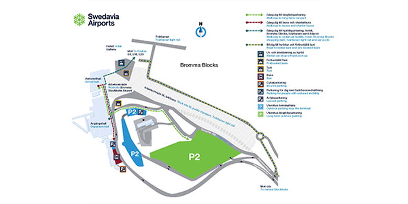
Information about the new entrance road at Bromma Stockholm Airport
On October 27, the airport will start using a new temporary entrance road because the public transport company SL will take over the existing road and incorporate it in the work under way to expand Tvärbanan, the new crosstown railway. At the same time, work will begin on the new pick-up facilities for buses and taxis outside the arrival hall.

On October 27, the airport will start using a new temporary entrance road because the public transport company SL will take over the existing road and incorporate it in the work under way to expand Tvärbanan, the new crosstown railway. At the same time, work will begin on the new pick-up facilities for buses and taxis outside the arrival hall. This means that all buses, both SL buses and Flygbussarna airport coaches, will be relocated for a period of time. Signs will be posted to make it easier for arriving and departing passengers. There will also be some change for rental cars. From now on, they will be picked up and dropped off at the same place, which is the airport’s car rental parking facility by Bromma Blocks. Signs to this parking facility will also be posted, and the car rental offices can likewise provide support. Taxis will be parked to the right of the arrival hall, which is basically the same place where prebooked taxis are also currently parked, adjacent to the car rental parking facility by Bromma Blocks.
The temporary airport entrance road will no longer be used and the drop-off and pick-up facilities for taxis and buses will be completed in July 2019. However, there will be minor changes in the airport’s drop-off and pick-up facilities throughout this period. Afterwards, SL will return the land, and the road entrance will revert to the same stretch of road. Nevertheless, we would urge passengers to exercise caution since airport facilities will look different for a while if people are arriving in their own car, by foot or arriving/departing by bus or rental car during this period.
Above is a map that shows the location of the different facilities. For bigger image (pdf) ckick here.